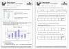
Here is another Level 1-2 variant on the classic ‘Smarties’ investigation which incorporates the use of a PC and Excel. I stopped using Smarties and Skittles because of the health and hygiene issues.
Level
Level 2
Level 1
Maths
Averages and range
Collect organise represent
Functional Maths - handling information and data
ICT
Functional Skills ICT: Developing, presenting and communicating information
An E3-L1 Functional Maths, English and ICT task first used with learners at Leyton Orient Community Sports Programme. Plan and cost a restaurant meal for 20 officials (originally held at Frank and Benny’s, Chingford, but you will need to provide menus from a favourite local restaurant or chain) and then present your results in a spreadsheet..
Level
Level 1
Entry Level 3
English
Functional Skills English
Maths
Functional Maths
ICT
Functional Skills ICT: Developing, presenting and communicating information
Functional Skills ICT: Finding and selecting information
Fabulous set of resources used first with OCNW Construction students but also suitable for building services and engineering. Written for L1 Functional Skills students but can easily be simplified/extended to cover Entry 3 and Level 2.
Includes detailed mapping to Functional English, Functional Maths and Functional ICT.
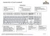
Very handy help sheet – ideal for Functional Skills ICT Entry 3- L1 or any basic ICT class. Also provides useful practice in reading and following directions.
Level
Level 1
Entry Level 3
ICT
Functional Skills ICT: Finding and selecting information
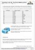
A clear guidebook to computers (mouse, keyboard) and to using Microsoft Word. Ideal for E3-L1 Functional ICT and ECDL (European computer driving licence).
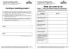
I created this resource as practice in data handling for a Level 1 Functional Maths group and it covers skills from Entry 3 to Level 2. It includes creating tallies and charts, using a distance chart, calculating average and range, and working with money. It is fully mapped to the Functional Maths criteria and includes an answer sheet.
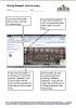
My students are 16-18, and have a limited knowledge of geography, so I included an outline map of the UK (not included in the resource) and got them to use a road map to find and mark the cities and towns that are on the distance chart.