E3-L2 Travelling in the UK Functional Maths
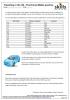
I created this resource as practice in data handling for a Level 1 Functional Maths group and it covers skills from Entry 3 to Level 2. It includes creating tallies and charts, using a distance chart, calculating average and range, and working with money. It is fully mapped to the Functional Maths criteria and includes an answer sheet.
My students are 16-18, and have a limited knowledge of geography, so I included an outline map of the UK (not included in the resource) and got them to use a road map to find and mark the cities and towns that are on the distance chart.
This gave the lesson a more ‘useful feel’ as learners often question how lessons fit in with their own lives. So, I hope it has improved their knowledge of their own country as well as their mathematics! We also looked at a road map (and the distance chart included in the resource) and discussed where they live / have been / places of interest / distances across the country.
- Log in to post comments